BY PCC STAFF
FORT MADISON - Area weather experts have issued a winter storm warning for today through 7 a.m. Friday morning.
According to the National Weather Service, rain and snow were expected to begin falling in the area at around 2 p.m. Thursday afternoon with a a total daytime accumulation of up to two inches.
Precipitation is predicted to change over to all snow by Thursday night with additional accumulations projected at 6 to 10 inches by early Friday morning.
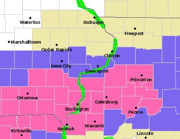
Weather models have the heaviest snow hitting the northern Missouri, southern Iowa band up to Interstate 80, and into west central Illinois, but as is normally the case, forecasters can't predict where the heaviest precipitation will occur.
The warning area has Lee County in the southernmost part of the band and a shift to the north could result in reduced snowfall over the duration of the weather advisory.
Snow is predicted to continue overnight when rain will enter the mix at about 9 a.m. Friday morning. The snow is expected to be heavy and wet with reduced visibility during the higher snowfall rates.
Power outages are also a possibility due to the predicted heavy, wet snowfall.
Temperatures are expected in the range of 32 degrees overnight to 45 on Friday with winds in the 20-25 mph range Thursday night and slowing down to 5 to 15 mph range out of the northeast on Friday.


Comments
No comments on this item Please log in to comment by clicking here